
Wednesday, October 11th
Day 3. It’s Wednesday morning, and we wake up to a blanket of fog mixed with heavy smoke hovering over the town of Sonoma. Last night Ellen and I drove up Highway 12 as far as the road block going into Glen Ellen, where we witnessed rivers of flame that looked like lava coming down the canyon behind Hamel Family Winery. We know the fires are still raging to the north and east from TV/Internet but we can’t see a thing. The devil is out there, we just can’t see him at the moment. Misinformation and rumors are still rampant, so there is something to be said for seeing the fire yourself. Not anytime soon, though. Visibility is probably 1000 feet, and masks are required to go outside.
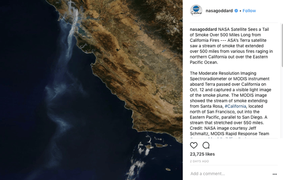
Image: NASA puts out an image on their Instagram account that shows the smoke trail from space. It can be seen as far down as San Diego! Source: NASA.
A New York Times article breaks on how the wildfires will take a toll on wine country tourism. Yeah, no kidding Sherlock. I start to think about the future impact to Sojourn. No customers coming to Sojourn in the near to medium term is a really bad business thought, but it’s a reality I better start to think about and soon. October, in the middle of harvest is traditionally our busiest month of the year in the Sojourn Tasting Salon. Ouch. That sucks.
Fire maps dominate my Internet surfing along with weather conditions. They are calling for 30+ mph winds tonight from the north, and we are considering vacating town. There are fires up on Moon Mountain Road, Cavedale Road and Norrbom Road to the north, and above the Gun Bun and Scribe wineries to the east. Nice. Semi-surrounded. We have reasonably good intel that authorities are considering evacuating the entire town of Sonoma later today. Ellen’s car and my pickup truck are packed; we’re just sizing up if and when to vacate and where.
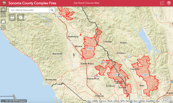
Image: Firemap from Sonoma County showing the acreage of each of these fires. These maps are constantly refreshed, as we watch to see how close the red outline gets to us.
I am up in Santa Rosa with a plan of trying to access the winery, still behind barricades now manned by National Guardsmen with big guns. We decide to close the office in Sonoma and send everyone home. What to pack? Computers, employee records, contracts, licensing info. Check. Grab personal items from desks.
Lots of folks in Sonoma have already left town, and it’s time to get the kids out too. Ellen heads to Menlo Park to one of her friend’s houses, while I stay behind to quarterback operations from Sonoma this afternoon. As the afternoon wears on, the fog lifts and we can see a giant nuclear bomb style mushroom cloud rising straight up from behind the town square. Wow I think, as I snap a quick photo.
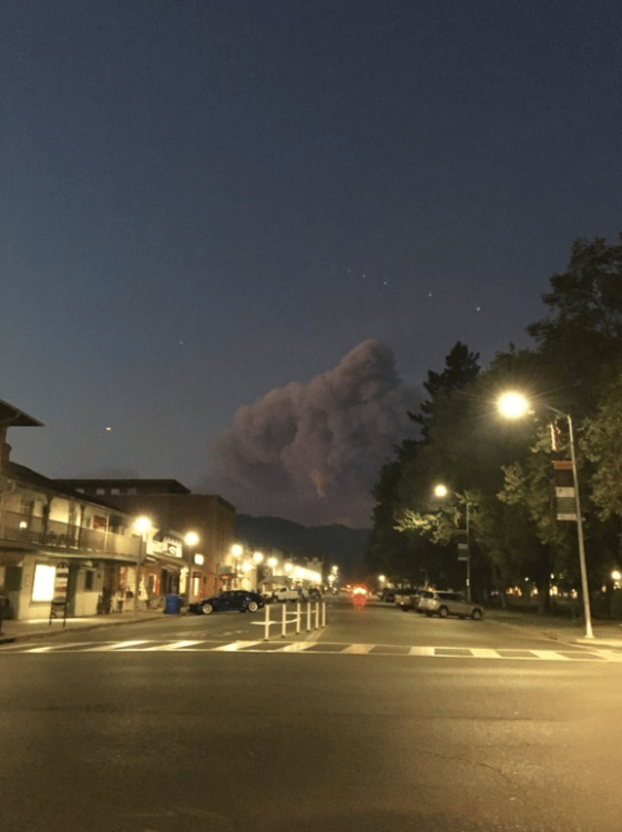
Image: Looking north up 1st Street West in the town of Sonoma. It is definitely time to leave!
Everyone is glued to their phone because we are now all subscribed to Nixle Alerts, which send us text messages seemingly every 30 minutes about a new evacuation order. These come in two formats: Advisory, which is “keep a bag packed and be ready to go at any point,” and Mandatory, which is “time to go right now.” If you do leave and get outside of mandatory evacuation zone lines you can’t get back in. At 6:30 pm authorities issue an advisory evacuation for everything north of the Sonoma Square. Some areas north and northeast of town are already under mandatory evacuation orders.
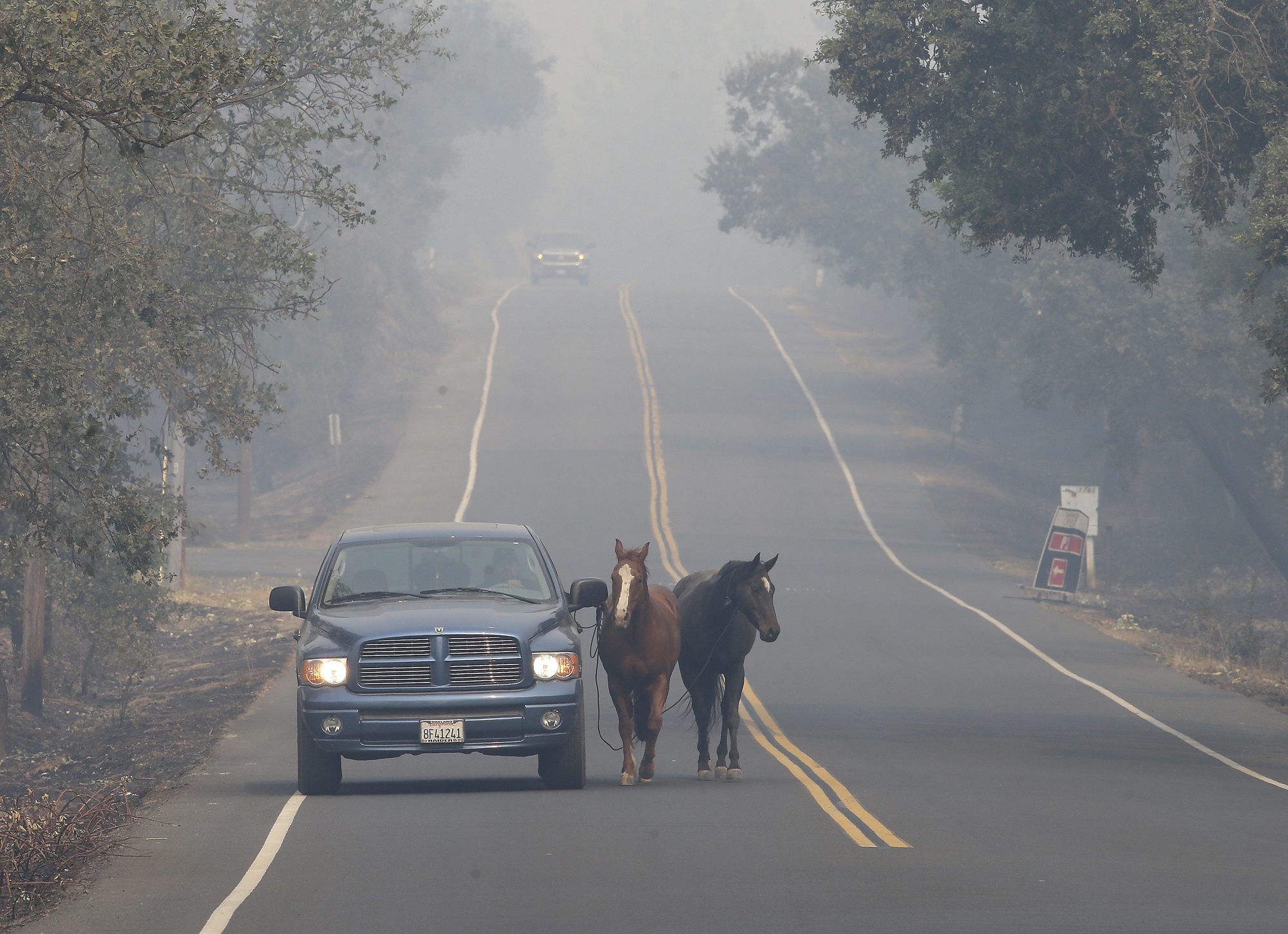
Image: It's not just the people that have to be evacuated, it is also the animals. We live in farm country afterall. Whether it is a pet, livestock or your business, there is no great solution for the animals. Makeshift animal shelters are popping up at fairgrounds all around the county.
Sonoma County Sheriff vehicles are driving through town with bullhorns blaring, “Fire is coming. Time to leave now.” Would authorities really let the town of Sonoma burn? The historic square? Many folks in town are flood watering their landscaping, raking up loose leaves and setting up elaborate sprinkler systems on their roofs to run 7x24 ahead of the forecasted winds and fires on the move. What should my strategy be? I quickly decide that time is money and this is why I have insurance. It’s just a house; if it burns I’ll deal with it later.
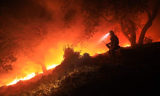
Image: Firefighters assess the current state of the Nuns Fire and strategize about their next move. Source: Press Democrat.
I decide to wait out the traffic jams watching Waze/Google Maps and leave just after 8pm to join Ellen in Menlo Park. As I turn right on Highway 29 headed south I see massive fires up on the hills straight to the East above the Coomsville Napa neighborhood. Once in Menlo Park I have 12 Explorer windows open on my computer to monitor wind conditions all over wine country. The major forecasted wind is delayed, I fall asleep in a chair around midnight feeling helpless and guilty for leaving Sonoma...
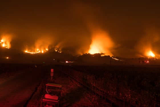
Image: This is an image that I have deemed the "Oh Sh@t" photo. Fires seemingly all around.
Recent Posts